Pinka
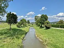
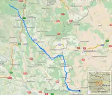
The Pinka (German pronunciation: [ˈpɪŋka] ( listen)) is a river in Central Europe with a length of approximately 100 km (60 mi). Its basin area is 1,299 km2 (502 sq mi).[2] Its source is located in Styria, eastern Austria, next to the provincial border of Burgenland. It passes into Hungary between the villages of Burg and Felsőcsatár, and crosses the Austrian-Hungarian border five times. Further it flows into the Rába river near Körmend. Its main tributary is the Strem.
| Pinka | |
|---|---|
 | |
 | |
| Location | |
| Countries | Austria and Hungary |
| Physical characteristics | |
| Mouth | |
• location | Rába near Körmend |
• coordinates | 46.9991°N 16.5897°E |
| Length | 99.8 km (62.0 mi) [1] |
| Basin size | 1,299 km2 (502 sq mi) |
| Basin features | |
| Progression | Rába→ Danube→ Black Sea |
Important towns on its course are Pinkafeld (Hungarian: Pinkafő) and Oberwart (Hungarian: Felsőőr).
References
- Digitaler Atlas der Steiermark (Styria)
- "Flächenverzeichnis der Flussgebiete: Leitha-, Rabnitz- und Raabgebiet" (PDF). Beiträge zur Hydrografie Österreichs Heft 63. December 2014. p. 132.
This article is issued from Wikipedia. The text is licensed under Creative Commons - Attribution - Sharealike. Additional terms may apply for the media files.